
We left home Sunday, fought the traffic on I-75, and finally got smart, got off and took the back roads south. Spent the night in Huron Ohio (which is on Lake Erie just to be confusing).
Monday we stopped in Lorain, then spent most of an hour trying to find a good view of the Cleveland Lights, then went on to Fairport and Dunkirk. The weekend had been a lighthouse festival at Dunkirk, so the staff was worn out and closed early (but we got in before they closed at 3).
Tuesday we stopped in at South Buffalo before going on the Mother's. We celebrated my birthday with Mary and Bob at the Hamilton Inn.
You can see the lights beginning at http://www.lighthousesrus.org/Erie.htm#OH10
Wednesday, August 20, 2008
Saturday, July 19, 2008
Delaware
This concludes this trip, so there will be no further postings here till something new happens.
Needless to say, we were on the road fairly early, but found a Perkin's just down the street and had a good breakfast. And our directions to the Elm Tree light were spot on, so that worked. But, our directions to the Princess Bay light weren't good enough, we were in the right area, but didn't follow through and walk the right path, so 1 out of 2 for Tuesday morning in New York. We then went south (bought gas the second we entered New Jersey at significantly cheaper prices) and stopped at the southernmost light in New Jersey.
This impressive looking structure (Tinicum) is standing in the middle of a park with ball parks on both sides of it. At one time it was the center of 2 ranges, but at this time neither front range is in existance. This light however is still used for navigation, and periodically it is open for viewing.
We then crossed over into Delaware and saw some lights there (http://www.lighthousesrus.org/NorthAtlantic/Delaware.htm). Several of these lights are pretty unimpressive, and we had to drive from exit 12 to 13 3 times on I-495 to get the photo of the Bellvue light.
Our last photo of the day was the Marcus Hook Rear range.

As you can see, the keeper's house is all boarded up, we're told that it is now privately owned.
The rest of the trip into Virginia was without note (which we appreciated).
Connecticut to New York (July 14)
We planned to do the drive from Concord to Virginia in 2 easy days rather than attempting to do it in one hard day. So, we pulled out my trusty lighthouse maps, put the coordinates into my street atlas program, and headed down the road.
We took the safe way out of Boston - went north to I-495 and avoided the beltway (which is pretty bad most of the time and terrible during rush hour. We really had good success until we got to Avery (you can see this all at http://www.lighthousesrus.org/RICT.htm#CT1). When we got there, our directions were convoluted and drove around and drove around and finally gave up. As we were driving back north to the bridge to New London, I spotted New London Ledge (out in the water), so I parked the car to get a photo of it.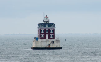
When I got over to the wall to take this photo, I saw that I could also get a good photo of New London harbor from the same place, so got 2 things at once. When I got back in the car, Marnie commented that this sounded like a reference place in our directions, so we did a quick U-turn, and sure 'nuf, there was the Avery light we'd been trying to find in the first place.
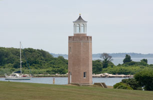
This really is just a faux light - built by UConn to look nice, but it does look nice, so is recorded as such.
The next stop was Coney Island, so we headed into New York. The driving wasn't too bad, but it was 5:00 before we got to the light. This light is inside a gated community, and it took several tries to find the gate that allowed visitors in (and then all they did was take a photo copy of our ID). So we got that light too.

Finding a motel on Staten Island was not as much fun. The first place we tried specialized in rooms by the hour, the second one (which I took) was not as clean we'd like and turned out not to have air conditioning. But it worked. After dinner, we went out and got two more lighthouse photos (better than sitting in the room (see http://www.lighthousesrus.org/NewYorkE.htm#NY44)).
The fun story was our stop at the Staten Island Range Light (below).
Salem, MA (July 12)
While we were in Concord, we made a day trip down to Salem to see the witch's museum. Had lunch down on the waterfront and got a photo of the light on the wharf (http://www.lighthousesrus.org/Mass.htm#MA14).
We finished the trolley tour, then tried to drive out to the Fort Pickering light. It's at the end of a park that charges a $20 admission fee, so we drove around trying to get another view. Finally saw a light and I got out to get photos, got invited by the residence to walk across his lawn to get a better picture and found out there were two lights visible (in opposite directions).

The one on the left is hospital point, the one on the right is Fort Pickering. So, in being cheap and not paying my $20, I got 2 pictures instead of 1.
We finished the trolley tour, then tried to drive out to the Fort Pickering light. It's at the end of a park that charges a $20 admission fee, so we drove around trying to get another view. Finally saw a light and I got out to get photos, got invited by the residence to walk across his lawn to get a better picture and found out there were two lights visible (in opposite directions).
The one on the left is hospital point, the one on the right is Fort Pickering. So, in being cheap and not paying my $20, I got 2 pictures instead of 1.
Saturday, July 12, 2008
Concord, MA
The trip down from Lubec went smoothly yesterday and we arrived here about 3:15. By that time, 128/I-95 northbound was a mess, but southbound was busy, but moving well.
We checked out Stephen and Tia's apt, then went to dinner a short walk from there. Then we finished the Australia pictures and showed off my short set of the trip so far.
Today we went over to Salem to see the Witch exhibits. At lunch we were also able to get a picture of the Derby Wharf light, and on the way out of town, wanted to get a photo of the Fort Pickering light. They wanted $20 admission, so we tried to get a photo from a nearby point. Not only did we get the photo much cheaper, we also got a photo of Hospital Point.
All 3 photos are now on the web site athttp://www.lighthousesrus.org/Mass.htm#MA11. We're off to dinner in the Back Bay
Thursday, July 10, 2008
Back to Maine
Today started out pretty frustrating, cold, rain, fog, ... The first 2 lights washed out - or should I say fogged out. The next one was on the end of a wharf, we found that, but it was rotting away and from the shore, you couldn't see the end of the wharf to know if there was a light there or not.
We finally found 2 and put those on the New Bruswick pages (however, my photos are not , as good as the others due to the fog, but my photos win anyway.) Then we crossed into the US, and located the Whitlock Mills light - it's the northernmost light in Maine. I thought it was going to be tough, but it's well marked on the highway
We then drove down to Lubec and while the road was fine, when we went to see the shoreline, the wind was blowing in from the south and the fog was so thick you couldn't see the bridge from the shore.
We checked into the Home Port Inn, same place we used 4 years ago, then crossed back into Canada to see East Quoddy. At low tide, you can walk across (for $5 that is) but the tide was coming in and it rises 5 feet every hour. So we got our pictures from the shore. Very picturesque spot I must say.

We came back to the Inn and I've uploaded the pages (slow, but it worked) so you can see changes on both New Brunswick and Maine.
Wednesday, July 09, 2008
Nova Scotia to New Brunswick
We had 3 left over lights near Digby, so got up early and made the rounds. Absolutely no problems and got 3 almost identical photos. You can see them at http://www.lighthousesrus.org/Canada/NovaScotia.htm#NS10.
We got an early lunch as check in time for the ferry was 12 and still got there early - with no problems on check in. The ferry arrived at 12 (as advertized) and we started loading about 12:30. At that point, I could find my receipt, but not my ticket. The good news is that while the check in fellow was trying to verify the receipt by radio, we found the ticket. The ferry is your typical ocean going ferry, load from the rear, exit front, or visa versa. In this case, we loaded from the rear.
We got an early lunch as check in time for the ferry was 12 and still got there early - with no problems on check in. The ferry arrived at 12 (as advertized) and we started loading about 12:30. At that point, I could find my receipt, but not my ticket. The good news is that while the check in fellow was trying to verify the receipt by radio, we found the ticket. The ferry is your typical ocean going ferry, load from the rear, exit front, or visa versa. In this case, we loaded from the rear.
We got a nice view of Prim Point as we left (but as you can see, the fog was beginning to roll in.

Three (not very exciting) hours later, we are pulling into the harbour at St. John. Or so we think because the engines are slowing, but it's hard to even see the lookout on the front of the boat. The dock was literally beside the boat before you could see it (and the lights were on!)
No problem unloading, once the GPS found the satellites, we found the recommended motel. But, ... it was booked, the next alternative was booked and the hostess was not at all comforting. So, ... we headed west. However, the first motel out of town had the vacancy sign on, and we got a room. Not the 4 star Hilton but clean, with a full kitchenette, and as you can see, Internet.
So, shortly we head for town and see what we can find that looks good to eat at. We do a bunch of lights tomorrow and end up in Lubec Maine and will be at Stephen & Tia's Friday night (God willing and the creek don't rise.)
Tuesday, July 08, 2008
Digby Neck

There's a very narrow peninsula south (and west) of Digby and today we ran that. We waited for the fog to clear, then got on the road anyway. Nearly and hour to the first ferry, the rest of the hour to the second ferry and you are on Brier Island. Saw the two lights (in the fog) there, one, as you can see, is fairly dramatic.
Had lunch at the only option in town (but good), then ran south on the island to attempt to see Peter's Island. On the second try, you could see the island, hear the fog horn, but couldn't see the light.
Returned to Long Island to see Boar's Head. Had to park on a hill on a narrow lane, then a 1 km walk (up some 200') but found the light and got a good photo.
Back home at 4, and the web site is updated. We've got two leftovers we'd planned to get to today, so tomorrow will be early in order to see them and catch the 1:00 ferry.
Monday, July 07, 2008
Evangeline Trail

We are approaching the end of Nova Scotia! We had a bunch of lights to see today, but no where near as many miles to cross, so we got breakfast at the motel, and headed for Cape Forchu. However, it was foggy in Yarmouth, and got thicker as we went south.
It wasn't as bad as I expected, you actually could see the tower from the parking lot.
But, two more lights that we wanted to see were in the water, and no way could we see even to the edge of the low tide.
However, we did get photos of 10 lights and you can see the others starting at http://www.lighthousesrus.org/Canada/NovaScotia.htm.
Mom has had a grand time checking out all of the tourist information spots, and most of them have pretty good data, and a variety of reference data. So, it's been good so far.
Tonight and tomorrow we are staying in Digby and tomorrow we'll head down the peninsula to catch the lights there. Wednesday we'll catch the ferry to New Brunswick (1 PM, so we'll arrive there middle afternoon).
Dad
Sunday, July 06, 2008
Lighthouse Trail
We really should have used 2 days between Halifax and Yarmouth. Better planning next time.
I wanted to start early as we had a full day, so tried to find OJ and a bun and bring them back to the hotel. Nothing in Halifax was open! So, we got in the car, found gas and the convenience store had juices, and drove on to Peggy's Cove.

Halifax was hot and sticky. The driving was full sun. Peggy's cove was cool and foggy. It's a popular tourist spot and when we got there, there was already one bus at the restaurant. But we easily got breakfast, and, as we sat there, 6 busses pulled in. Local staff said 2 cruise ships had arrived in Halifax last night, and this was just the first wave. So, we happily got our photos, got our postcards, and ran.
No luck at the next light (too much fog) but good success at Medway and several others. It was a mixed day, some successes, some failures. We were surprised at lunch, not only did we find some place to eat, we had a choice and it included both fast food and leisurely lunch. Given the time schedule, we took fast food.
Got into Yarmouth and took the host's recommendation for dinner. Pretty low-class bar is what she recommended, but the food was good and the price for two was less than a single entree last night.
So, I'll get to work editing the web site so y'all can look.
Dad
Saturday, July 05, 2008
Halifax
After breakfast this morning, we went 3 blocks up the hill to the citadel. This is the third built here (the others were intended to be temporary, and they were). It is staffed with recreators of the Scottish regiment that was here 1860s to 1870s. We took the guided tour and had a good time.

On the way back, we stopped in St. Paul's, the first Anglican church in Canada. The wood was cut and pre-numbered in Boston, then shipped here and assembled as a kit. The outside is pretty plain, but the inside has beautiful windows.

After lunch, we took a harbor tour and got two more lighthouses (NS 57 and 58 if you want to see them.)
My internet time is about to run out, so I'll post this.
Friday, July 04, 2008
Marine Trail
We started off bright and early this morning (breakfast at 7), got to the causeway just as a boat was entering the lock (so that's the first 20 minutes of the trip). Got some gas ($30, about 5 gallons), didn't see another gas station till I'd almost run out (2PM).

Things went smoothly till we got to Isaac's Harbor. Directions told us to drive 4 miles, then walk 5 minutes. We drove 2 miles to the locked barrier, and tried to walk. It was pretty forest, but we did the arithmetic and figured we had 2 miles more to walk in, then another 2 to walk out. So, ... we bailed out.
Came back to the main road and started looking around. Sure 'nuf, you can see the light from the road. Not close, but that's what long lenses are for.

We grabbed lunch at the visitors center (only place we'd seen since breakfast) - cone of ice cream, augmented by raisons from our supplies and proceeded on. Shortly we saw a note that said "road ends in 300 meters." Sure 'nuf, it did. The good news is that it was a ferry, so only had to wait 15 minutes, we didn't need to backtrack.

After that, all went well. We arrived in Halifax, our hotel had a reservation, we found dinner. As of Saturday morning, I have updated the web site and you can see these lights starting at http://www.lighthousesrus.org/Canada/NovaScotia.htm#NS65, and plans for tomorrow (see the citadel, take harbor tour, nice dinner) may not allow a web site update tomorrow. So next news is probably Monday.
Thursday, July 03, 2008
Fleur de Lis Trail
Today finished off our time in Cape Breton. Nice warm morning, 72 after breakfast. We had breakfast in the hotel, packed the car, and took off. By 9:30 we'd gone as far as my farthest point yesterday. (on the website, our first (physical) light is at http://www.lighthousesrus.org/Canada/NovaScotia.htm#NS91, the last one for today is NS 95R). We started at Glace Bay, then got a total miss at Main a Dieu.
Went on to Louisbourg and ended up going through the town 4 times. The light is on the north end of town, but the road signs to the light are only visible from the south. So we went to the fortress, which it turns out is an amazing reconstruction, on the order of Williamsburg, so a whole day or more. Luckily, we got revised directions before we started that and went back through town to get to the light. As we pulled into town, the fog rolled in and the temperature dropped to 61. At the light, there were force 5 winds, very interesting, very accurate, but darn cold.
We went back into town for lunch, then headed south for our next light. It turns out that Delorme doesn't know that the road we were on doesn't go through. So we came back through town to get west.
At this point we ignored the mapping program and followed the signs for the Fleur de Lis trail, and they worked fine. But having lost all that time in transit, we only saw 5 lights today.

We are now just east of Port Hastings, ready to leave the Cape after breakfast tomorrow. We can see boats approaching the bridge from our front porch.
Wednesday, July 02, 2008
Bras d'Or trail
It turns out that the tire problem wasn't a puncture, but a break in the sidewall. Thus unrepairable. It took two tries (better than I expected), but we found a service station that had the appropriate replacement. So, I left them with the wheel and told them I'd be back.
Mom and I then got breakfast on the street, split a scone and a bottle of orange juice, had more to eat and drink than at the restaurant, and paid far less.
Then mom started laundry, and I headed north (and east this time). I crossed the mountain range (234 meters) and got a good look of my first light (McNeil's point) from the bridge, but that was my last good look. So came back, walked out on the bridge and got my photo from their. (You can see today starting at http://www.lighthousesrus.org/Canada/NovaScotia.htm#NS84M but it skips around a bit more than usual, so look for the large "New" markings.)
The next two lights went fairly easily, but to get to Point Aconi, they routed me over a dirt road. It got progressively worse, and I finally u-turned in front of a tree that was down. It was a narrow 3 point turn, I now have dirt in the trailer hitch.
But I got to Point Aconi, got some photos, and the, for the first time today, found both a gas station and a restaurant. Not wanting to gamble, I both filled up the car and ate lunch.
Got 3 more lights after lunch, then headed home to get the new tire. Decided to gamble on the "Man of War" light which theoretically has been dismantled. I found it, or at least the rear range. It was a 15 minute walk to the front range and I decided enough was enough.
Got home and the tire was mounted, but not balanced. Pushed them to get that done, then again to mount it, but it was still only 5 when I got back to the hotel.
Mom and I went out for a big dinner tonight -take home pizza, and ate it, shared some wine on the porch.
That pretty much finishes today
Tuesday, July 01, 2008
The Cabot Trail
The website for today is now finished. You can find 2 lights starting at http://www.lighthousesrus.org/Canada/NovaScotia.htm#NS85, then scroll to the very bottom of the page where there are 4 more.
As we left the hotel this morning, the "low tire pressure" light came on, so we stopped and added some air to the right front. The good news is it made it most of the way through the day before needing more air, but, after adding air at 3, it needed more by 4. So, the car now has a temporary tire on it (all shops of course are closed for Canada day). It looks like there is a good tire service just around the corner though, so early tomorrow should be possible.
Our first stop of the day was Ingonish. The light that was supposed to be there was just a post, but as you can see below, the bay is worth the stop just to photograph.

As we traveled, we enjoyed the variety of scenery. Parts of it, as mentioned previously, look like upstate New York, then you get a break in the trees and can see ocean, so you know it's not New York. Parts like above look like the Maine coast. Finally there are some mountains, like below.
These are typically only 400 meters high, but since the road starts at sea level, crosses the pass, and then returns to sea level, you get a lot of up and down. Probably didn't help the gas mileage and this morning I paid $1.52 per liter.
We got around the loop, saw all the lights we were supposed to, passed through the Cape Breton National Park, and since it's Canada Day, that was free. All in all, a good day, but now I need to edit pictures and web site.
In addition to being Canada Day, today is the 100 year anniversary of first flight in Canada, which happened from the Baddeck lake (in winter). So, we had special fireworks. Mom and I went down to the Lakeside Cafe, had a dessert, and watched the event. Very nice.
Dad
As we left the hotel this morning, the "low tire pressure" light came on, so we stopped and added some air to the right front. The good news is it made it most of the way through the day before needing more air, but, after adding air at 3, it needed more by 4. So, the car now has a temporary tire on it (all shops of course are closed for Canada day). It looks like there is a good tire service just around the corner though, so early tomorrow should be possible.
Our first stop of the day was Ingonish. The light that was supposed to be there was just a post, but as you can see below, the bay is worth the stop just to photograph.

As we traveled, we enjoyed the variety of scenery. Parts of it, as mentioned previously, look like upstate New York, then you get a break in the trees and can see ocean, so you know it's not New York. Parts like above look like the Maine coast. Finally there are some mountains, like below.

These are typically only 400 meters high, but since the road starts at sea level, crosses the pass, and then returns to sea level, you get a lot of up and down. Probably didn't help the gas mileage and this morning I paid $1.52 per liter.
We got around the loop, saw all the lights we were supposed to, passed through the Cape Breton National Park, and since it's Canada Day, that was free. All in all, a good day, but now I need to edit pictures and web site.

In addition to being Canada Day, today is the 100 year anniversary of first flight in Canada, which happened from the Baddeck lake (in winter). So, we had special fireworks. Mom and I went down to the Lakeside Cafe, had a dessert, and watched the event. Very nice.
Dad
Monday, June 30, 2008
Ceilidh Trail
The trail name is Gaelic, so pronounce it as quay-leigh (or phonetically kay-lee).
We actually finished the Sunshine trail this morning - having had a wonderful evening at the Victorian B&B last night. But we couldn't find the Havre Boucher light. We took the named exit, well, it turns out there are two of them, and wandered around for a while. Got close to the second light, then decided w/o a 4WD, that wasn't going to happen, so went back again. This time was a charm and we got both the front and the rear range lights.
The next stop would be on Cape Breton, so mom drove for a moment while I attempted to get organized. The bridge on the causeway opened, so there was a queue, and them mom was supposed to make a left turn into the spot where we could see the next light. We finally pulled off shortly later, and after 5 minutes the backlog went away, did a U-turn, and now a right turn was easy. That's Balache Point if you are following along (see http://www.lighthousesrus.org/Canada/NovaScotia.htm#NS75 is where we started).
We did a few more lights, and then had to stop at the Glennora Distillery. They follow Scotch traditions, but can't call it scotch as it's from Canada. Took the tour and it's much sweeter than I'm used to (instead of Sherry kegs, they use Jack Daniels kegs made of Apple wood), but good. Had lunch there, then Marnie drove (since I had a beer for lunch).
The country side here varies from upstate New York to California back country so quite varied. Mom got her exercise on that length. We then saw the Margaree range lights and on the way to the hotel, we stopped by Little Narrows.
Checked into the Inverary Resort and unloaded the car, bought some more beer, then I took a boat ride around the island to get those lights. So I got quite a few photos today. While I was on the boat ride, the local eagle nest was pointed out to me. Here she is:

Went to their casual dining room tonight and ate very well. So, life goes on.
Charles
Sunday, June 29, 2008
Sunrise Trail
Near the end of day, I commented to Marnie that this trail is missed named. Not only didn't we see the sun rise, we didn't see the sun, in fact it never got bright enough to even dig out the sunglasses to conquer the glare.

Oh, well.
Today we visited the lights on the north shore. You can see them starting at http://www.lighthousesrus.org/Canada/NovaScotia.htm#NS76. You'll note I'm now attaching "new" flags to the lights that are new. Big "new"s are today, small ones are yesterday. We visited them in the opposite order of the web page.
Coldspring head went pretty well (we just got lost on the trails.) Pugwash was a no-show,  couldn't find the light. When we got to Pictou Harbor, the instructions got serious. Cross the creek, follow the bank walk the beach. This is the creek I had cross (yes, Marnie stayed in the car with her book). I did get to the light, did get back, but it took about 20 minutes, and no, I didn't get excessively muddy, or wet. You can see on the web site that I got both the front range and the rear range photos.
 couldn't find the light. When we got to Pictou Harbor, the instructions got serious. Cross the creek, follow the bank walk the beach. This is the creek I had cross (yes, Marnie stayed in the car with her book). I did get to the light, did get back, but it took about 20 minutes, and no, I didn't get excessively muddy, or wet. You can see on the web site that I got both the front range and the rear range photos.
We got a nice lunch downtown, then headed for the next light. Because of construction, it was a convoluted route, and when we got there, it turned out that rumors were correct, there's not much of interest at Pubnico bar anymore.
Oh, well ...
We then headed for our last light. An hours drive away. The rain picked up, the wind picked up, it was pretty nasty driving. But we got that photo, and a new one of Arsaig. I suspect it's a faux light, but authentically built in 2007.
We got to the Victoria Inn (a bed and breakfast) about 4:30, so it wasn't a bad day. Had 3 recommendations for supper, Numbers 1 & 2 were closed (Sunday) but number 3 was pretty good, so not a bad deal.

Dad
Saturday, June 28, 2008
Glooscap Trail
Our first day in Nova Scotia has gone well. A little problem getting up (something about a time change), but otherwise it went well. As we headed south from the hotel on the Glooscap trail (the first of several planned lighthouse tours), the highway looked much like the back country in New York.
We managed to find a light that I hadn't been able to pin down - the Apple River light. (We did have to ask a local for help.) That was a significant step.

Then we got to the Cape d'Or (cape of Gold) and the scenery is just gorgeous. It took 2 tries to get the directions right, and then 4 1/2 km of very steep dirt roads to get there, but it was worth it.

We saw 4 more lights that you can see at http://www.lighthousesrus.org/Canada/NovaScotia.htm#NS17B (You'll note I've date stamped the ones we saw today.
We cut today short so we had time to get home and do some buying.
We went downtown for dinner and to see what we can find on the historic main street. The architecture of the buildings is neat, but the selection of restaurants is poor. We ate well where we went, but it was mostly good luck.
Charles
Friday, June 27, 2008
New Brunswick
We really did a quick trip through New Brunswick today (we'll do more after Nova Scotia). I had originally planned a 10 hour day, and we quickly decided we didn't like that idea. So, I cut out a bunch of stops. About mid-day, Mom was having lighthouse withdrawal, so we did 3 just before leaving New Brunswick. We are now at the Comfort Inn of Amherst NS, and will be here through tomorrow if you need to contact us ((902) 667-0404, room 208).
As we left Quebec, we stopped in Carleton as it was convenient to the highway. As I looked at the web site, I found I had two Carletons, and this picture was posted on the wrong one. So, I fixed that.

We then crossed over into New Brunswick and saw the Cambleton light, then had lunch and ran south. When we stopped for gas I noted the time and we are now on Atlantic time. Therefore we'll go to dinner soon and I'll update the web page later.
Dad
Thursday, June 26, 2008
Gaspe peninsula
We are now around the Gaspe peninsula and will enter New Brunswick tomorrow. We're running behind, but could be behinder. When we got to the National Park where the Cap Gaspe light is located, the girl at the check in was nice enough to say we had a 5 km walk from the parking lot to the light. Since we were already late, we didn't add another 2 hours to our day and did a quick U-turn.
The area started out flat and coastline. It quickly got hilly, then mountainy, but still coast line. Beautiful scenery, but if you don't like to hike or climb, we wonder what you would do.


We are staying tonight in Chandler, cheapest motel of the trip. They are obviously rennovating, our door frame is 1/2 painted.
You can see the lights we've seen today at http://www.lighthousesrus.org/Canada/Quebec.htm#QE16. I am updating this as we speak, so how current that will be depends on how quickly you look at it after I post this note.
Wednesday, June 25, 2008
Montreal to Matane
We slept in this morning, didn't get on the road till 8:30 or so. First two lights were "no shows" and I began to get discouraged (but not unexpected). But then we found a group of range lights (large day mark, light at the top). (These start at http://www.lighthousesrus.org/Canada/Quebec.htm#QC2028.)
After we passed Quebec city, we had a long haul to run. Beautiful country, but lots of miles (or, up here, even more Km). But we finally got to Point au Pere and saw a non traditional Canadian lighthouse.
We did make it to Matane for dinner, are staying in an older motel (so I have to sit near the office to get Internet), had a wonderful dinner, and are ready for tomorrow. Our room is on the waterfront side, so nice place to stay. Updates will follow.
Dad
After we passed Quebec city, we had a long haul to run. Beautiful country, but lots of miles (or, up here, even more Km). But we finally got to Point au Pere and saw a non traditional Canadian lighthouse.
We did make it to Matane for dinner, are staying
 in an older motel (so I have to sit near the office to get Internet), had a wonderful dinner, and are ready for tomorrow. Our room is on the waterfront side, so nice place to stay. Updates will follow.
Dad
Tuesday, June 24, 2008
Montreal
I think I'm going to adjust my day. In the previous days, I got all the photos edited, loaded them up to Flickr, then did the web site, then wrote the blog.
Well, I haven't yet been able to load anything to Flickr, the web site is about 80% done, and it's time to close it for a day.
So, ... in the future (I know, promises, promises, ...) I intend to post this first. Then, as time allows, I'll catch up. So, it could be you'll read this, and later say "what? he's changed things on the blog". Yes I can do that, and will (or at least might).
Fairly easy start of the day, breakfast at Denny's, 2 hours on the road, changed drivers, and then we got to Montreal. Got new pictures of Dixie Rear Range (couldn't find the front range), and both Lachine lights (see http://www.lighthousesrus.org/Canada/Quebec.htm). Got lunch and went downtown.
That's where the fun began. We were told to exit the tunnel and take a left - couldn't find the road number. Delorme got very upset and told us to turn around at a no U-turn spot, then turn left at a no turn spot, ... We finally got where we wanted to go, but mostly by following the general context, not the specific directions. Parked and got a picture of Ile Ste.Helene (next on Quebec page).
Left town and followed the GPS, and this time it found 2 lights (for which I had poor directions, but geocoordinates I didn't trust) impecablly. (No, I don't trust this spelling checker either.) You can page down to see the Vercheres lights.
Leaving them, we got an ice cream, changed drivers and I started to find a place for the night. Marnie was following the GPS and said "were you intending us to take a ferry?" The correct answer was "no", but checking the GPS, it was right about the ferry (and wrong about how to get to it). Unlike Wolf Island, (a) we paid a fee ($7.50), drove right on (no wait), crossed smoothly and got off where we expected to be.
Found a Day's Inn at the expressway exit (we were looking for the Comfort Inn across the way), went downtown, got an excellent supper, and came back to find out there wasn't enough time to really finish this right.
So, ... updates will follow.
Dad
Well, I haven't yet been able to load anything to Flickr, the web site is about 80% done, and it's time to close it for a day.
So, ... in the future (I know, promises, promises, ...) I intend to post this first. Then, as time allows, I'll catch up. So, it could be you'll read this, and later say "what? he's changed things on the blog". Yes I can do that, and will (or at least might).
Fairly easy start of the day, breakfast at Denny's, 2 hours on the road, changed drivers, and then we got to Montreal. Got new pictures of Dixie Rear Range (couldn't find the front range), and both Lachine lights (see http://www.lighthousesrus.org/Canada/Quebec.htm). Got lunch and went downtown.
That's where the fun began. We were told to exit the tunnel and take a left - couldn't find the road number. Delorme got very upset and told us to turn around at a no U-turn spot, then turn left at a no turn spot, ... We finally got where we wanted to go, but mostly by following the general context, not the specific directions. Parked and got a picture of Ile Ste.Helene (next on Quebec page).
Left town and followed the GPS, and this time it found 2 lights (for which I had poor directions, but geocoordinates I didn't trust) impecablly. (No, I don't trust this spelling checker either.) You can page down to see the Vercheres lights.
Leaving them, we got an ice cream, changed drivers and I started to find a place for the night.
 Marnie was following the GPS and said "were you intending us to take a ferry?" The correct answer was "no", but checking the GPS, it was right about the ferry (and wrong about how to get to it). Unlike Wolf Island, (a) we paid a fee ($7.50), drove right on (no wait), crossed smoothly and got off where we expected to be.
Found a Day's Inn at the expressway exit (we were looking for the Comfort Inn across the way), went downtown, got an excellent supper, and came back to find out there wasn't enough time to really finish this right.
So, ... updates will follow.
Dad
Monday, June 23, 2008
As the song goes - "Monday, Monday, how could you be this way?"
The day started well, breakfast at the Holiday Inn, a quick stop to get the geo coordinates on the [now renamed] Point Edward Rear Range, and on we went. Nothing dramatic till we got to Kingston.

There was a 45 minute wait for the ferry. When the ferry got in (late, but we'd been warned), the car wouldn't start. A short investigation proved that the lights (required in Ontario) were still on, but we missed that ferry till we could get a jump start. Mom persuaded me to not give in, so we took the next ferry after recharging the battery (and much worry each time we had to restart the car).

Took the ferry to Wolfe Island. Drove to the southern tip of Wolfe, and after two tries got the driveway for the ferry to Simcoe Island. Drove the full length of Simcoe Island, and there (ta da!) was Nine Mile Point lighthouse.
Got the 5:30 ferry back, got a room at the Day's Inn, found a restaurant , and now we are both ready to quit for the day.

Sunday, June 22, 2008
Off to Nova Sotia (via Ontario, Quebec, New Brunswick)
Mom and I left Midland a bit after 1, dropped Bonnie off and headed south (and east). Heavy traffic on I-75, but light on I-69 and the wait at the bridge wasn't long (just aggrevating as our line went about 1 car for 3 cars on both sides of us.)

We had intended to break into this lighthouse trip easy. No lights today (stop at Sarnia, don't do the Port Huron lights), only 1 light tomorrow (Kingston, God willing), 3 lights on Tuesday (west of Montreal and then downtown.)
But then, after dinner we went out to Point Edward (right under the bridge.) Got a nice picture of Fort Gratiot.
It looks like we found a new light range (as in undocumented, it looks like it's been here a while. I call this the Sarnia Range.


Oh, yes, we got some neat sunset pictures.


Things will pick up after this. Stay tuned.
Charles
Charles
Subscribe to:
Posts (Atom)