
We left home Sunday, fought the traffic on I-75, and finally got smart, got off and took the back roads south. Spent the night in Huron Ohio (which is on Lake Erie just to be confusing).
Monday we stopped in Lorain, then spent most of an hour trying to find a good view of the Cleveland Lights, then went on to Fairport and Dunkirk. The weekend had been a lighthouse festival at Dunkirk, so the staff was worn out and closed early (but we got in before they closed at 3).
Tuesday we stopped in at South Buffalo before going on the Mother's. We celebrated my birthday with Mary and Bob at the Hamilton Inn.
You can see the lights beginning at http://www.lighthousesrus.org/Erie.htm#OH10
Wednesday, August 20, 2008
Saturday, July 19, 2008
Delaware
This concludes this trip, so there will be no further postings here till something new happens.
Needless to say, we were on the road fairly early, but found a Perkin's just down the street and had a good breakfast. And our directions to the Elm Tree light were spot on, so that worked. But, our directions to the Princess Bay light weren't good enough, we were in the right area, but didn't follow through and walk the right path, so 1 out of 2 for Tuesday morning in New York. We then went south (bought gas the second we entered New Jersey at significantly cheaper prices) and stopped at the southernmost light in New Jersey.
This impressive looking structure (Tinicum) is standing in the middle of a park with ball parks on both sides of it. At one time it was the center of 2 ranges, but at this time neither front range is in existance. This light however is still used for navigation, and periodically it is open for viewing.
We then crossed over into Delaware and saw some lights there (http://www.lighthousesrus.org/NorthAtlantic/Delaware.htm). Several of these lights are pretty unimpressive, and we had to drive from exit 12 to 13 3 times on I-495 to get the photo of the Bellvue light.
Our last photo of the day was the Marcus Hook Rear range.

As you can see, the keeper's house is all boarded up, we're told that it is now privately owned.
The rest of the trip into Virginia was without note (which we appreciated).
Connecticut to New York (July 14)
We planned to do the drive from Concord to Virginia in 2 easy days rather than attempting to do it in one hard day. So, we pulled out my trusty lighthouse maps, put the coordinates into my street atlas program, and headed down the road.
We took the safe way out of Boston - went north to I-495 and avoided the beltway (which is pretty bad most of the time and terrible during rush hour. We really had good success until we got to Avery (you can see this all at http://www.lighthousesrus.org/RICT.htm#CT1). When we got there, our directions were convoluted and drove around and drove around and finally gave up. As we were driving back north to the bridge to New London, I spotted New London Ledge (out in the water), so I parked the car to get a photo of it.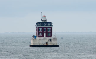
When I got over to the wall to take this photo, I saw that I could also get a good photo of New London harbor from the same place, so got 2 things at once. When I got back in the car, Marnie commented that this sounded like a reference place in our directions, so we did a quick U-turn, and sure 'nuf, there was the Avery light we'd been trying to find in the first place.
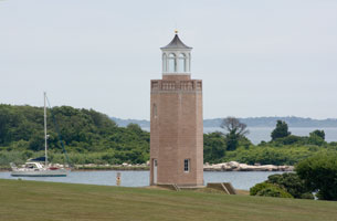
This really is just a faux light - built by UConn to look nice, but it does look nice, so is recorded as such.
The next stop was Coney Island, so we headed into New York. The driving wasn't too bad, but it was 5:00 before we got to the light. This light is inside a gated community, and it took several tries to find the gate that allowed visitors in (and then all they did was take a photo copy of our ID). So we got that light too.

Finding a motel on Staten Island was not as much fun. The first place we tried specialized in rooms by the hour, the second one (which I took) was not as clean we'd like and turned out not to have air conditioning. But it worked. After dinner, we went out and got two more lighthouse photos (better than sitting in the room (see http://www.lighthousesrus.org/NewYorkE.htm#NY44)).
The fun story was our stop at the Staten Island Range Light (below).
Salem, MA (July 12)
While we were in Concord, we made a day trip down to Salem to see the witch's museum. Had lunch down on the waterfront and got a photo of the light on the wharf (http://www.lighthousesrus.org/Mass.htm#MA14).
We finished the trolley tour, then tried to drive out to the Fort Pickering light. It's at the end of a park that charges a $20 admission fee, so we drove around trying to get another view. Finally saw a light and I got out to get photos, got invited by the residence to walk across his lawn to get a better picture and found out there were two lights visible (in opposite directions).

The one on the left is hospital point, the one on the right is Fort Pickering. So, in being cheap and not paying my $20, I got 2 pictures instead of 1.
We finished the trolley tour, then tried to drive out to the Fort Pickering light. It's at the end of a park that charges a $20 admission fee, so we drove around trying to get another view. Finally saw a light and I got out to get photos, got invited by the residence to walk across his lawn to get a better picture and found out there were two lights visible (in opposite directions).
The one on the left is hospital point, the one on the right is Fort Pickering. So, in being cheap and not paying my $20, I got 2 pictures instead of 1.
Saturday, July 12, 2008
Concord, MA
The trip down from Lubec went smoothly yesterday and we arrived here about 3:15. By that time, 128/I-95 northbound was a mess, but southbound was busy, but moving well.
We checked out Stephen and Tia's apt, then went to dinner a short walk from there. Then we finished the Australia pictures and showed off my short set of the trip so far.
Today we went over to Salem to see the Witch exhibits. At lunch we were also able to get a picture of the Derby Wharf light, and on the way out of town, wanted to get a photo of the Fort Pickering light. They wanted $20 admission, so we tried to get a photo from a nearby point. Not only did we get the photo much cheaper, we also got a photo of Hospital Point.
All 3 photos are now on the web site athttp://www.lighthousesrus.org/Mass.htm#MA11. We're off to dinner in the Back Bay
Thursday, July 10, 2008
Back to Maine
Today started out pretty frustrating, cold, rain, fog, ... The first 2 lights washed out - or should I say fogged out. The next one was on the end of a wharf, we found that, but it was rotting away and from the shore, you couldn't see the end of the wharf to know if there was a light there or not.
We finally found 2 and put those on the New Bruswick pages (however, my photos are not , as good as the others due to the fog, but my photos win anyway.) Then we crossed into the US, and located the Whitlock Mills light - it's the northernmost light in Maine. I thought it was going to be tough, but it's well marked on the highway
We then drove down to Lubec and while the road was fine, when we went to see the shoreline, the wind was blowing in from the south and the fog was so thick you couldn't see the bridge from the shore.
We checked into the Home Port Inn, same place we used 4 years ago, then crossed back into Canada to see East Quoddy. At low tide, you can walk across (for $5 that is) but the tide was coming in and it rises 5 feet every hour. So we got our pictures from the shore. Very picturesque spot I must say.

We came back to the Inn and I've uploaded the pages (slow, but it worked) so you can see changes on both New Brunswick and Maine.
Wednesday, July 09, 2008
Nova Scotia to New Brunswick
We had 3 left over lights near Digby, so got up early and made the rounds. Absolutely no problems and got 3 almost identical photos. You can see them at http://www.lighthousesrus.org/Canada/NovaScotia.htm#NS10.
We got an early lunch as check in time for the ferry was 12 and still got there early - with no problems on check in. The ferry arrived at 12 (as advertized) and we started loading about 12:30. At that point, I could find my receipt, but not my ticket. The good news is that while the check in fellow was trying to verify the receipt by radio, we found the ticket. The ferry is your typical ocean going ferry, load from the rear, exit front, or visa versa. In this case, we loaded from the rear.
We got an early lunch as check in time for the ferry was 12 and still got there early - with no problems on check in. The ferry arrived at 12 (as advertized) and we started loading about 12:30. At that point, I could find my receipt, but not my ticket. The good news is that while the check in fellow was trying to verify the receipt by radio, we found the ticket. The ferry is your typical ocean going ferry, load from the rear, exit front, or visa versa. In this case, we loaded from the rear.
We got a nice view of Prim Point as we left (but as you can see, the fog was beginning to roll in.

Three (not very exciting) hours later, we are pulling into the harbour at St. John. Or so we think because the engines are slowing, but it's hard to even see the lookout on the front of the boat. The dock was literally beside the boat before you could see it (and the lights were on!)
No problem unloading, once the GPS found the satellites, we found the recommended motel. But, ... it was booked, the next alternative was booked and the hostess was not at all comforting. So, ... we headed west. However, the first motel out of town had the vacancy sign on, and we got a room. Not the 4 star Hilton but clean, with a full kitchenette, and as you can see, Internet.
So, shortly we head for town and see what we can find that looks good to eat at. We do a bunch of lights tomorrow and end up in Lubec Maine and will be at Stephen & Tia's Friday night (God willing and the creek don't rise.)
Subscribe to:
Posts (Atom)